
Fil:Indian Rashtrakuta Empire map.svg

Opprinnelig fil (SVG-fil, standardstørrelse 1 639 × 1 852 piksler, filstørrelse: 410 KB)
| Denne filen er fra Wikimedia Commons og kan brukes av andre prosjekter. Informasjonen fra filbeskrivelsessiden vises nedenfor. |
| Tittel |
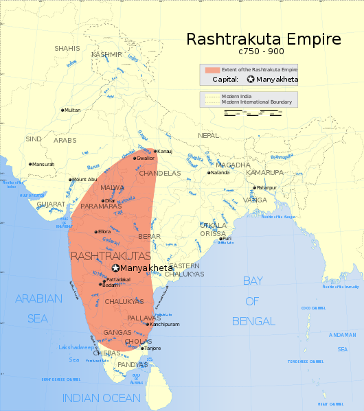
The Rashtrakuta Empire 750-900BC |
|||||||||
| Beskrivelse |
Map showing the extent of the Rashtrakuta empires. Extent of Rashtrakuta Empire, 780 C.E. |
|||||||||
| Kartforklaring |
 |
|||||||||
| Dato | ||||||||||
| Kilde |
Eget verk |
|||||||||
| Skaper | ||||||||||
| Tillatelse (Gjenbruk av denne filen) |
Jeg, rettighetsinnehaver av dette arbeidet, publiserer det herved under følgende lisens: Denne filen er lisensiert under lisensen Creative Commons Navngivelse-DelPåSammeVilkår 3.0 Unported
|
|||||||||
| Geotemporale data | ||||||||||
| Forestilt dato | andre halvdel av 20. århundre og 21. århundre | |||||||||
| Kartprojeksjon | conic | |||||||||
| Avgrensningsboks |
|
|||||||||
| Georeferering | If inappropriate please set warp_status = skip to hide. | |||||||||
| Arkivdata | ||||||||||
| Merknader | Part of WikiProject India Maps | |||||||||

Notes
Depiction of India's borders
- The territorial boundaries of India are shown as per the actual ground situation in accordance with international practices followed by the United Nations ([1], [2]) and the National Geographic Society ([3], [4])
- This map is meant to be for illustrative purpose only and is not authenticated by official government sources. Please check the list of sources and references used to create the map for a measure of accuracy and verifiability.
- The usage of these maps in India, Pakistan and China are governed by different laws that restrict depictions of boundaries other than what is officially recognized by the state. Please check local laws and modify the map accordingly before use.
Explanation of disputed boundaries


- Boundary of Indian claim : The territory India claims is legally theirs, but the claim is disputed by China and Pakistan.
- Line of Control/Line of Conflict : The de facto administrative boundary recognised by the international community. This UN ceasefire line is considered as a temporary solution to an ongoing conflict since the departure of the British Raj.
Borders of disputed regions
The depicted extent of the former territory of the British Indian Empire, succeeded by Republic of India, may not be accepted by few countries as legal due to ongoing border disputes:
- The northern Himalayan region of the disputed territory Indian-administered Kashmir is claimed by India including (Pakistan-administered Kashmir) and the Chinese-occupied territory of (Ladakh plateau). Since 1972, it is divided between all three countries. See also Line of Control and Line of Actual Control.
- Siachen glacier (shown white) is an actively contested region between India and Pakistan. Since 1984, the region is under Indian control.
- The northeastern territory of Arunachal Pradesh is almost entirely claimed by China as part of its Tibetan territory.
- Minor areas of eastern Kashmir's Ladakh division, Himachal Pradesh and Uttarakhand on the Chinese frontier are claimed by China. These areas are under Indian control.
- A small area of Uttarakhand adjoining the Nepal border along the Sarda river is disputed between the two countries.
For a detailed map of all disputed regions in South Asia, see Image:India disputed areas map.svg
Internal borders
The borders of the state of Meghalaya, Assam and Arunachal Pradesh are shown as interpreted from the North-Eastern Areas (Reorganisation) Act, 1971, but has yet to be verified.
Territorial waters
The limit of the territorial waters of India extends to twelve nautical miles measured from the appropriate baseline. See this for more information.
derivative works
Derivative works of this file:
Filhistorikk
Klikk på et tidspunkt for å vise filen slik den var på det tidspunktet.
| Dato/klokkeslett | Miniatyrbilde | Dimensjoner | Bruker | Kommentar | |
|---|---|---|---|---|---|
| nåværende | 9. jul. 2013 kl. 04:47 | | 1 639 × 1 852 (410 KB) | AnonMoos | remove Adobe cruft |
| 27. apr. 2007 kl. 20:57 |  | 1 639 × 1 852 (451 KB) | Planemad | {{WikiProject_India_Maps |Title=The Rashtrakuta Empire 750-900BC |Description=Map showing the extent of the Rashtrakuta empires. {{legend|#FF9F80|Extent of Rashtrakuta Empire, 780 C.E.}} |Source= "John Keay, History of India, 2000, Grove publications, Ne |
Filbruk
Den følgende siden bruker denne filen:
Global filbruk
Følgende andre wikier bruker denne filen:
- Bruk i ar.wikipedia.org
- Bruk i azb.wikipedia.org
- Bruk i ba.wikipedia.org
- Bruk i bn.wikipedia.org
- Bruk i br.wikipedia.org
- Bruk i ca.wikipedia.org
- Bruk i en.wikipedia.org
- Middle kingdoms of India
- Timeline of scientific discoveries
- Rashtrakuta Empire
- Shilahara
- North Karnataka
- Wikipedia talk:WikiProject Indian maps
- History of Karnataka
- Portal:India/Selected articles/Archive
- Political history of medieval Karnataka
- Portal:India/SC Summary/SA Rashtrakuta Dynasty
- Chalukyas of Vemulavada
- List of Hindu empires and dynasties
- Bruk i en.wiktionary.org
- Bruk i fa.wikipedia.org
- Bruk i fi.wikipedia.org
- Bruk i fr.wikipedia.org
- Bruk i gu.wikipedia.org
- Bruk i hi.wikipedia.org
- Bruk i hu.wikipedia.org
- Bruk i hy.wikipedia.org
- Bruk i id.wikipedia.org
- Bruk i it.wikipedia.org
- Bruk i ja.wikipedia.org
- Bruk i ka.wikipedia.org
- Bruk i kn.wikipedia.org
- Bruk i ko.wikipedia.org
- Bruk i lt.wikipedia.org
- Bruk i ml.wikipedia.org
- Bruk i mr.wikipedia.org
- Bruk i ms.wikipedia.org
- Bruk i ne.wikipedia.org
Vis mer global bruk av denne filen.