
Fil:12nm hypothetical Territorial Sea compared with Northern Limit Line, North Korea.jpg

Opprinnelig fil (1 315 × 938 piksler, filstørrelse: 147 KB, MIME-type: image/jpeg)
| Denne filen er fra Wikimedia Commons og kan brukes av andre prosjekter. Informasjonen fra filbeskrivelsessiden vises nedenfor. |
Beskrivelse
| Beskrivelse |
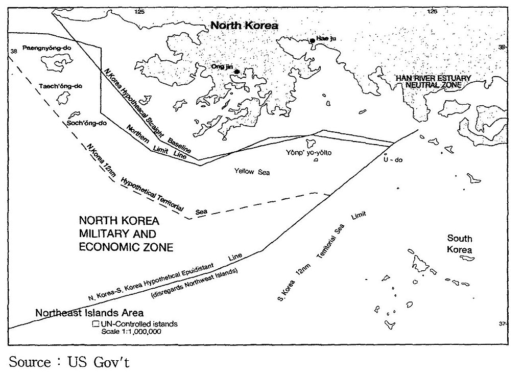
English: A US Government map showing where a North Korean 12 nautical mile Territorial Waters limit would be, when disregarding the north west UN Command islands, compared to the UN Command created Northern Limit Line. |
| Dato | Ukjent dato |
| Kilde | http://118.129.184.33/pub/docu/kr/AM/06/AM062001B01/IMAGE/AM06-2001-B01-0210-01.jpg |
| Opphavsperson | US Government |
| Andre versjoner |
Derivative works of this file: Yeonpyeong Island live firing range map.png:  |
Map taken from HTML version of the paper, which included this US Government credited map:
Seong-Geol Hong, Sun-Pyo Kim, Hyung-Ki Lee (2001-06-30). "Fisheries Cooperation and Maritime Delimitation Issues between North Korea and Its Neighboring Countries". Ocean Policy Research 16 (1): 191-216. Korea Maritime Institute. Archived from the original on 2011-07-23. Retrieved on 2010-11-28.
HTML version of paper: http://118.129.184.33/pub/docu/kr/AM/06/AM062001B01/AM06-2001-B01-006.HTM[dead link]
According to a Korean Central News Agency article "Northern Limit Line rejected" of 2 August 2002[1] archive copy at the Wayback Machine "the U.S. government distributed [this map] to the participants in the UN conference on maritime law held in the U.S. in 1980". The map is also published in paper by Kim, Jung-Gun (Spring-Summer 1985). "Reflections on the attitude of North Korea toward the Law of the Sea (UNCLOS III Treaty)". Asian Perspective 9 (1)., and John Barry Kotch & Michael Abbey in Asian Perspective, Vol. 27, No. 2, 2003, pp. 175-204 archive copy at the Wayback Machine.
The CIA report "The West Coast Korean Islands", BGI RP 74-9, January 1974 (Declassified 2000-04-18 as CIA-RDP-84-00825R000300120001-7)[2] describes this, or a very similar, map. However the map itself is redacted from the declassified version of the report.
Lisensiering
This work is in the public domain in the United States because it is a work prepared by an officer or employee of the United States Government as part of that person’s official duties under the terms of Title 17, Chapter 1, Section 105 of the US Code.
Note: This only applies to original works of the Federal Government and not to the work of any individual U.S. state, territory, commonwealth, county, municipality, or any other subdivision. This template also does not apply to postage stamp designs published by the United States Postal Service since 1978. (See § 313.6(C)(1) of Compendium of U.S. Copyright Office Practices). It also does not apply to certain US coins; see The US Mint Terms of Use.
|
 | |
| Denne filen har blitt identifisert til å være fri for kjente restriksjoner under lov om opphavsrett, inkludert alle relaterte og nærstående rettigheter. | ||
Filhistorikk
Klikk på et tidspunkt for å vise filen slik den var på det tidspunktet.
| Dato/klokkeslett | Miniatyrbilde | Dimensjoner | Bruker | Kommentar | |
|---|---|---|---|---|---|
| nåværende | 29. nov. 2010 kl. 01:05 | | 1 315 × 938 (147 KB) | Rwendland | {{Information |Description={{en|1=A US Government map showing where a North Korean 12 nautical mile Territorial Waters limit would be, when disregarding the north west UN Command islands, compared to the UN Command created Northern Limit Line.}} |Source=h |
Filbruk
Den følgende siden bruker denne filen:
Global filbruk
Følgende andre wikier bruker denne filen:
- Bruk i en.wikipedia.org
- Bruk i fr.wikipedia.org
- Bruk i id.wikipedia.org
- Bruk i ko.wikipedia.org
- Bruk i ru.wikipedia.org
- Bruk i uk.wikipedia.org
- Bruk i vi.wikipedia.org
- Bruk i zh.wikipedia.org