
Fil:Occupied Palestinian Territories.jpg

Størrelse på denne forhåndsvisningen: 393 × 599 piksler. Andre oppløsninger: 157 × 240 piksler | 315 × 480 piksler | 504 × 768 piksler | 672 × 1 024 piksler | 1 895 × 2 889 piksler.
Opprinnelig fil (1 895 × 2 889 piksler, filstørrelse: 949 KB, MIME-type: image/jpeg)
| Denne filen er fra Wikimedia Commons og kan brukes av andre prosjekter. Informasjonen fra filbeskrivelsessiden vises nedenfor. |
Beskrivelse
| Beskrivelse |
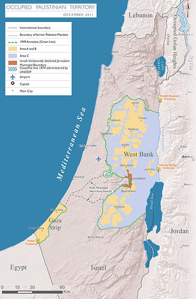
English: Map of the Occupied Palestinian Territories (West Bank and Gaza Strip), marked by the Green Line. Based on Reference Map: occupied Palestinian territory: Overview Map, as of December 2011. Published by United Nations Office for the Coordination of Humanitarian Affairs (OCHAoPt), 25 January 2012
العربية: خريطة للأراضي الفلسطينية المحتلة (الضفة الغربية وقطاع غزة) ، مميزة بالخط الأخضر. استنادًا إلى الخريطة المرجعية: "الأراضي الفلسطينية المحتلة: خريطة عامة" ، اعتبارًا من ديسمبر 2011. تم النشر بواسطة مكتب الأمم المتحدة لتنسيق الشؤون الإنسانية (OCHAoPt ) ، 25 يناير 2012 |
| Dato | |
| Kilde | Eget verk, based on http://www.ochaopt.org/documents/ochaopt_atlas_opt_general_december2011.pdf on [1] |
| Opphavsperson | Wickey-nl |

|
Dette bildet bør gjenskapes med hjelp av vektorgrafikk som en SVG-fil. Dette har flere fordeler, se Commons:Media for cleanup for mer informasjon. Hvis en SVG-fil med dette bildet er tilgjengelig, vennligst last den opp. Etter opplasting erstatt denne malen med {{vector version available|nytt bilde.svg}}.
|


Lisensiering
Jeg, rettighetsinnehaver av dette arbeidet, publiserer det herved under følgende lisens:
Denne filen er lisensiert under lisensen Creative Commons Navngivelse-DelPåSammeVilkår 3.0 Unported
- Du står fritt:
- til å dele – til å kopiere, distribuere og overføre verket
- til å blande – til å endre verket
- Under de følgende betingelsene:
- navngivelse – Du må kreditere verket på passende vis, lenke til lisensen og indikere hvorvidt det har blitt gjort endringer. Du kan gjøre det på enhver rimelig måte, men ikke på en måte som antyder at lisensgiveren støtter deg eller din bruk av verket.
- del på samme vilkår – Dersom du remikser, omarbeider eller på annen måte bygger på dette verket, må du kun distribuere resultatet under den samme eller en samsvarende lisens som denne.

Filhistorikk
Klikk på et tidspunkt for å vise filen slik den var på det tidspunktet.
| Dato/klokkeslett | Miniatyrbilde | Dimensjoner | Bruker | Kommentar | |
|---|---|---|---|---|---|
| nåværende | 25. mar. 2014 kl. 19:08 | | 1 895 × 2 889 (949 KB) | Wickey-nl | User created page with UploadWizard |
Filbruk
De følgende 2 sidene bruker denne filen:
Global filbruk
Følgende andre wikier bruker denne filen:
- Bruk i af.wikipedia.org
- Bruk i ar.wikipedia.org
- Bruk i az.wikipedia.org
- Bruk i bh.wikipedia.org
- Bruk i bn.wikipedia.org
- Bruk i bug.wikipedia.org
- Bruk i cs.wikipedia.org
- Bruk i da.wikipedia.org
- Bruk i de.wikipedia.org
- Bruk i el.wikipedia.org
- Bruk i en.wikipedia.org
- Israeli–Palestinian conflict
- Palestinian territories
- Israeli-occupied territories
- Frozen conflict
- United Nations Security Council Resolution 1515
- Talk:Israeli–Palestinian conflict/Archive 18
- United States involvement in regime change
- Boycott, Divestment and Sanctions
- Two-state solution
- Talk:State of Palestine/Archive 12
- Freedom of religion in Asia by country
- User:Falcaorib
- From the river to the sea
- User:Christophervincent01
- Bruk i es.wikipedia.org
- Bruk i et.wikipedia.org
- Bruk i fa.wikipedia.org
- Bruk i fi.wikipedia.org
- Bruk i fy.wikipedia.org
- Bruk i gl.wikipedia.org
- Bruk i he.wikipedia.org
- Bruk i hu.wikipedia.org
- Bruk i id.wikipedia.org
- Bruk i io.wikipedia.org
- Bruk i it.wikipedia.org
- Bruk i ja.wikipedia.org
- Bruk i la.wikipedia.org
Vis mer global bruk av denne filen.