
Fil:Ilrail1.jpg
Størrelse på denne forhåndsvisningen: 276 × 598 piksler. Andre oppløsninger: 111 × 240 piksler | 325 × 704 piksler.
Opprinnelig fil (325 × 704 piksler, filstørrelse: 66 KB, MIME-type: image/jpeg)
| Denne filen er fra Wikimedia Commons og kan brukes av andre prosjekter. Informasjonen fra filbeskrivelsessiden vises nedenfor. |
Beskrivelse
| Beskrivelse |
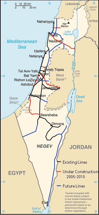
Map of en:Israel Railways' Network Image has been modified by Wikiliki to display Israel Railways rail lines. Original image source is from the CIA world factbook. |
| Kilde | CIA World Fact Book |
| Opphavsperson | CIA |

|
Dette bildet bør gjenskapes med hjelp av vektorgrafikk som en SVG-fil. Dette har flere fordeler, se Commons:Media for cleanup for mer informasjon. Hvis en SVG-fil med dette bildet er tilgjengelig, vennligst last den opp. Etter opplasting erstatt denne malen med {{vector version available|nytt bilde.svg}}.
|


Lisensiering
This work is in the public domain in the United States because it is a work prepared by an officer or employee of the United States Government as part of that person’s official duties under the terms of Title 17, Chapter 1, Section 105 of the US Code.
Note: This only applies to original works of the Federal Government and not to the work of any individual U.S. state, territory, commonwealth, county, municipality, or any other subdivision. This template also does not apply to postage stamp designs published by the United States Postal Service since 1978. (See § 313.6(C)(1) of Compendium of U.S. Copyright Office Practices). It also does not apply to certain US coins; see The US Mint Terms of Use.
|
 | |
| Denne filen har blitt identifisert til å være fri for kjente restriksjoner under lov om opphavsrett, inkludert alle relaterte og nærstående rettigheter. | ||
Orginal opplastningslogg
The original description page was here. All following user names refer to en.wikipedia.
- 2005-09-09 16:59 Wikiliki 325×704×8 (67102 bytes) Map of Israel Railways' Network
- 2005-09-09 05:20 Wikiliki 325×703×8 (64975 bytes) Map of Israel Railways' Network
- 2005-09-09 05:08 Wikiliki 325×704×8 (67067 bytes) Map of Israel Railways' Network
- 2005-09-09 04:42 Wikiliki 325×704×8 (67145 bytes) Map of Israel Railways' Network
- 2005-09-09 04:29 Wikiliki 325×707×8 (67919 bytes) Map of Israel Railways' Network
- 2005-09-09 04:23 Wikiliki 325×704×8 (66984 bytes) Map of Israel Railways' Network
- 2005-09-09 04:21 Wikiliki 325×706×8 (68421 bytes) Map of Israel Railways' Network
- 2005-09-09 03:20 Wikiliki 325×706×8 (66967 bytes) Map of Israel Railways' Network
Filhistorikk
Klikk på et tidspunkt for å vise filen slik den var på det tidspunktet.
| Dato/klokkeslett | Miniatyrbilde | Dimensjoner | Bruker | Kommentar | |
|---|---|---|---|---|---|
| nåværende | 20. mai 2007 kl. 01:29 | | 325 × 704 (66 KB) | Yonidebest | {{Information |Description=Map of en:Israel Railways' Network Image has been modified by Wikiliki to display Israel Railways rail lines. Original image source is from the CIA world factbook. |Source=Originally from [http://en.wikipedia.org en.wikip |
Filbruk
Den følgende siden bruker denne filen:
Global filbruk
Følgende andre wikier bruker denne filen:
- Bruk i en.wikipedia.org
- Bruk i mk.wikipedia.org
- Bruk i pl.wikipedia.org
- Bruk i pt.wikipedia.org
- Bruk i ru.wikipedia.org