
Fil:KYphysiography.jpg

Størrelse på denne forhåndsvisningen: 800 × 353 piksler. Andre oppløsninger: 320 × 141 piksler | 824 × 364 piksler.
Opprinnelig fil (824 × 364 piksler, filstørrelse: 159 KB, MIME-type: image/jpeg)
| Denne filen er fra Wikimedia Commons og kan brukes av andre prosjekter. Informasjonen fra filbeskrivelsessiden vises nedenfor. |

|
Dette bildet bør gjenskapes med hjelp av vektorgrafikk som en SVG-fil. Dette har flere fordeler, se Commons:Media for cleanup for mer informasjon. Hvis en SVG-fil med dette bildet er tilgjengelig, vennligst last den opp. Etter opplasting erstatt denne malen med {{vector version available|nytt bilde.svg}}.
|


Beskrivelse
| Beskrivelse |
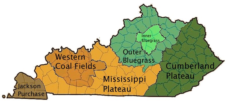
English: I created this image using Wikipedia's map of Kentucky counties.
|
| Dato | 1. mai 2007 (original upload date) |
| Kilde | Transferred from en.wikipedia to Commons by byankno1. |
| Opphavsperson | Lamontacranston at engelsk Wikipedia |
Lisensiering
| Dette verket har blitt frigitt til allmennheten av opphavspersonen Lamontacranston at engelsk Wikipedia. Dette gjelder på verdensbasis. I enkelte land kan dette være juridisk umulig. I så fall: Lamontacranston gir hvem som helst retten til å bruke dette verket for ethvert formål, uten noen vilkår, med mindre slike vilkår kreves ved lov. |
Orginal opplastningslogg
The original description page was here. All following user names refer to en.wikipedia.
- 2007-05-01 00:01 Lamontacranston 824×364× (162592 bytes) Bigger fonts. I created this image.
- 2007-04-30 23:54 Lamontacranston 824×364× (154693 bytes) Added text, improved edges, slightly lightened colors. I created the original.
- 2006-09-09 19:16 Lamontacranston 824×364× (55286 bytes) I created this image using Wikipedia's map of Kentucky counties.
Filhistorikk
Klikk på et tidspunkt for å vise filen slik den var på det tidspunktet.
| Dato/klokkeslett | Miniatyrbilde | Dimensjoner | Bruker | Kommentar | |
|---|---|---|---|---|---|
| nåværende | 18. nov. 2008 kl. 18:36 | | 824 × 364 (159 KB) | EpcotMagic | {{Information |Description={{en|I created this image using Wikipedia's map of Kentucky counties. *Dark green - Eastern Kentucky Coal fields (Cumberland Plateau) *Green - Outer Bluegrass *Light Green - Inner Bluegrass *Light Brown - Mississippi (Pennyroyal |
Filbruk
De følgende 2 sidene bruker denne filen:
Global filbruk
Følgende andre wikier bruker denne filen:
- Bruk i ar.wikipedia.org
- Bruk i de.wikipedia.org
- Bruk i el.wikipedia.org
- Bruk i en.wikipedia.org
- Bruk i es.wikipedia.org
- Bruk i fi.wikipedia.org
- Bruk i he.wikipedia.org
- Bruk i ia.wikipedia.org
- Bruk i id.wikipedia.org
- Bruk i it.wikipedia.org
- Bruk i ja.wikipedia.org
- Bruk i pt.wikipedia.org
- Bruk i sh.wikipedia.org
- Bruk i simple.wikipedia.org
- Bruk i sv.wikipedia.org
- Bruk i vi.wikipedia.org
- Bruk i zh.wikipedia.org